Hopper Project
-
High grade discoveries within a multifaceted hydrothermal system
-
Road accessible and close to power
-
Permitted for advanced exploration
CAVU Mining Corp. to earn up to a 70% interest as announced April 6, 2021.
The Hopper property hosts copper-gold skarn and porphyry mineralization in southwestern Yukon Territory. This 74 sq km road accessible property is located 22 km north of the Otter Falls hydroelectric generator within the Traditional Territory of the Champagne & Aishihik First Nation.
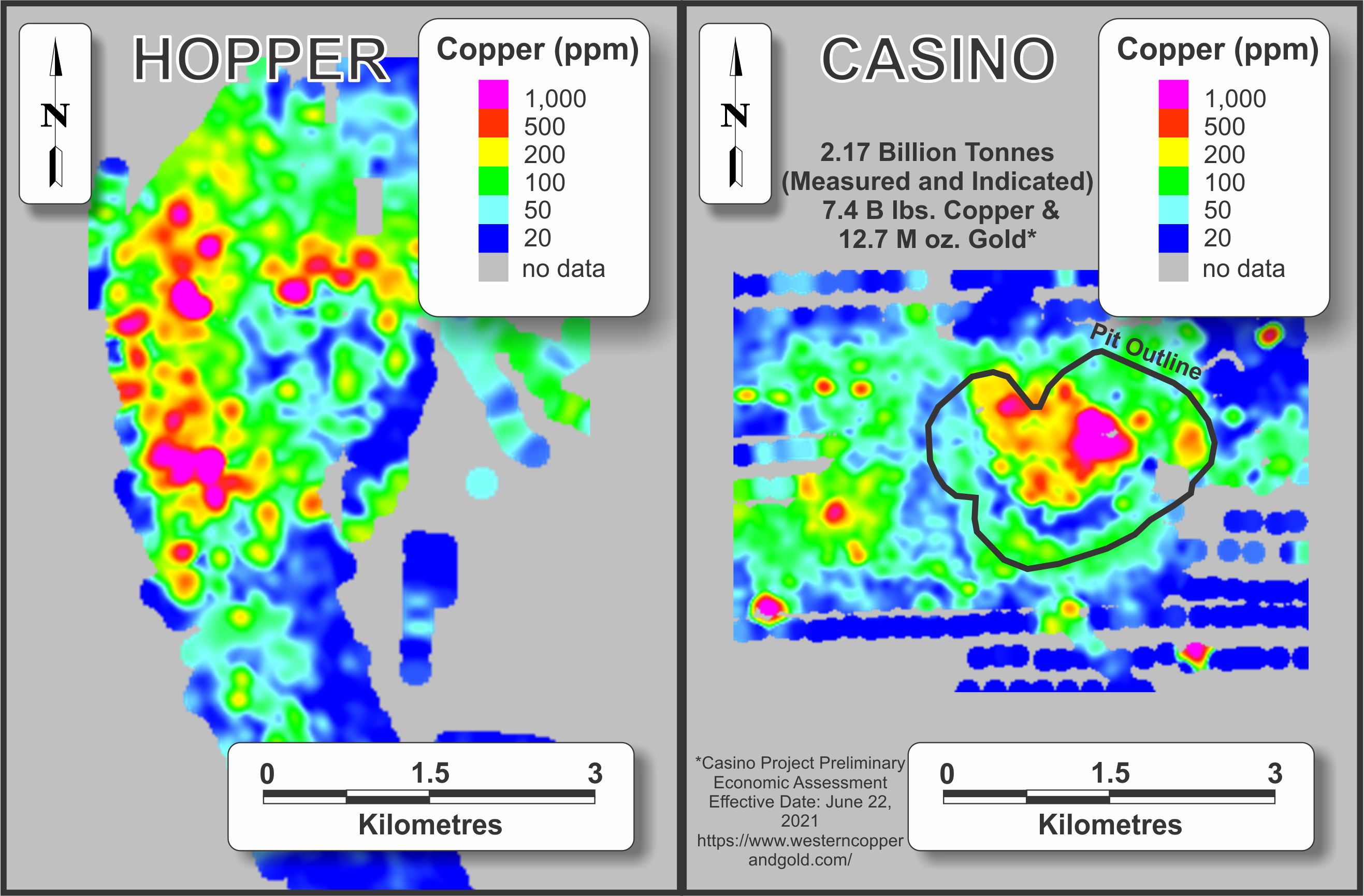
The property lies within the Yukon-Tanana Terrane. The oldest rocks in the area comprise Devonian to Mississippian quartz-biotite±muscovite schists, which are intercalated with lesser biotite-bearing quartzite and banded marble. This package is intruded by a Late Cretaceous (76.0±1.1 and 83.7±1.9 Ma) granodiorite pluton, which is informally called the Hopper Pluton. The age of the Hopper Pluton places it in the same metallogenic episode as the Patton Porphyry, which is the mineralizing pluton at Western Copper and Gold Corporation's Casino porphyry copper-gold-silver-molybdenum deposit located 190 km to the north-northwest. The Casino deposit contains 8.9 million ounces and 4.5 billion pounds in proven and probable ore reserves (mill reserves of 965.2 million tonnes grading 0.204% Cu, 0.240 g/t Au and 0.0227% Mo and heap leach reserves of 157.4 million tonnes grading 0.036% Cu and 0.292 g/t Au).
The mineralized hydrothermal system is centered on a porphyry-style copper zone that is flanked by stacked skarn horizons and distal veins. Historical work within the porphyry zone consisted of mechanized trenching and a number of widely spaced, very short percussion drill holes. The best results from this work were 0.52% copper over 45.72 m (trench) and 0.24% copper over 39.62 m (entire length of percussion drill hole). In 2015, a diamond drill hole targeting a chargeability anomaly which straddles the northern contact of the Hopper pluton yielded an interval that averaged 0.17% copper over 162.85 m. There are many other untested chargeability anomalies within and adjacent to the Hopper Pluton.
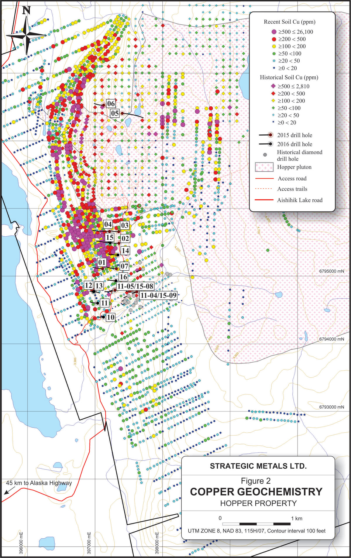
Prior to 2015, all diamond drilling on the property was done near a copper-rich skarn zone that outcrops in a creek bed, about 1,000 m southwest of the Hopper Pluton. Most of the historical holes were short and many of them were not analyzed for gold. Recent geochemical surveys outlined very strong copper, gold and molybdenum soil anomalies that cover a 3,600 by 2,500 m area. Only a small fraction of these anomalies have been tested by diamond drilling.
Collectively, the historical drill holes identified three laterally extensive skarn horizons (now named JG, AM and LV). These horizons are about 50 m apart stratigraphically and typically range from 2 to 20 m in thickness. The horizons strike northerly and dip shallowly (approximately 15°) to the east. They are locally cut by various types of steep intrusive dykes, some of which are weakly mineralized with copper or molybdenum. Many of the historical skarn intercepts are moderately to strongly mineralized with copper and gold. The best historical interval graded 1.94% copper and 0.87 g/t gold across 18.59 m (true thickness approximately 12 m).
A few of the historical drill holes extended somewhat deeper into the stratigraphic section and cut other copper-gold bearing skarn horizons. Most of these intercepts have not yet been assigned to specific horizons because they are too widely spaced for reliable correlations. Significantly, one of the deeper holes cut a skarn with a much higher gold content than has been reported from any of the upper horizons. This intercept returned 9.44 g/t gold with only 0.01% copper over 2 m within a broader interval that averaged 3.35 g/t gold and 0.43% copper across 7.5 m. Widely spaced diamond drilling in 2015 confirmed the presence of the deeper gold-rich skarn horizons with intersections including 12.15 g/t gold and 0.95% copper over a true width of 2.65 m and 43.6 g/t gold over 1.00 m true width. The 2015 intersections are over 360 m apart and occur at approximately the same stratigraphic level. Details of the 2015 program are summarized in the September 15, 2015 news release.
Table 1: Significant intercepts in 2015 drill holes, Hopper Project
| Hole | From (m) | To (m) | Interval (m)+ | Au (g/t) | Cu (%) | Ag (g/t) | Mo (ppm) |
| 15-01 | 90.59 | 92.26 | 1.67 | 0.119 | 0.57 | 4.44 | 0.31 |
| 284.29 | 286.94 | 2.65 | 12.15 | 0.95 | 5.45 | 3.24 | |
| 15-02 | 82.07 | 91.09 | 9.02 | 0.120 | 0.24 | 1.55 | 32.15 |
| 113.13 | 128.14 | 15.01 | 0.500 | 0.50 | 1.64 | 3.59 | |
| incl. | 121.7 | 128.14 | 6.44 | 1.013 | 1.00 | 3.86 | 3.99 |
| 136.6 | 138.6 | 2.00 | 0.142 | 0.70 | 4.44 | 2.11 | |
| 150.85 | 151.85 | 1.00 | 1.000 | 0.45 | 2.08 | 5.54 | |
| 204.9 | 205.9 | 1.00 | 0.723 | 0.79 | 4.24 | 3.78 | |
| 15-03 | 26.92 | 28.91 | 1.99 | 0.109 | 0.31 | 1.37 | 80.70 |
| 125.3 | 128.29 | 2.99 | 0.344 | 0.28 | 1.65 | 135.00 | |
| 266.61 | 276.15 | 9.54 | 1.010 | 0.35 | 1.79 | 45.43 | |
| 15-04 | 39.09 | 52.1 | 13.01 | 0.334 | 0.41 | 1.70 | 6.53 |
| 196.97 | 211.4 | 14.43 | 1.109 | 0.60 | 2.86 | 183.88 | |
| incl. | 202.52 | 207.00 | 4.48 | 2.40 | 1.03 | 3.98 | 253.12 |
| 325.24 | 498.91 | 173.67 | 0.002 | 0.01 | 0.09 | 157.57 | |
| 15-05 | 113.88 | 276.73 | 162.85 | 0.017 | 0.17 | 2.08 | 34.26 |
| incl. | 149.74 | 150.74 | 1.00 | 0.257 | 5.00 | 17.10 | 2730 |
| and incl. | 275.73 | 276.73 | 1.00 | 0.062 | 2.40 | 17.45 | 61.30 |
| 15-06 | 79.14 | 84.25 | 5.11 | 0.001 | 0.32 | 4.35 | 8.41 |
| 110.73 | 112.15 | 1.42 | 0.021 | 0.36 | 4.08 | 3.44 | |
| 186.23 | 188.98 | 2.75 | 0.031 | 0.78 | 3.68 | 63.96 | |
| 15-07 | 48.07 | 58.64 | 10.57 | 0.197 | 0.49 | 3.32 | 6.91 |
| incl. | 54.07 | 55.64 | 1.57 | 0.649 | 1.39 | 9.28 | 23.80 |
| 60.96 | 70.42 | 9.46 | 0.013 | 0.12 | 2.21 | 3172 | |
| 349.17 | 351.98 | 2.81 | 0.075 | 1.25 | 0.23 | 1.76 | |
| 369.35 | 370.71 | 1.36 | 0.294 | 0.46 | 1.56 | 2.57 | |
| 11-05/15-08* | 126.93 | 128.05 | 1.12 | 1.830 | 0.46 | 1.74 | 7.69 |
| 336.66 | 337.66 | 1.00 | 43.6 | 0.06 | 1.07 | 53.30 | |
| 341.49 | 342.63 | 1.14 | 0.204 | 0.31 | 1.91 | 45.40 | |
| 11-04/15-09* | 57.39 | 62.53 | 5.14 | 0.740 | 0.95 | 5.64 | 1.54 |
| 174.86 | 182.87 | 8.01 | 0.840 | 1.58 | 14.82 | 43.56 | |
| 339.33 | 340.33 | 1.00 | 0.171 | 0.67 | 3.93 | 83.70 |
*
holes 15-08 and 15-09 re-entered and deepened holes 11-05 and 11-04,
respectively.
+ intersected lengths are believed to represent 95
to 100% of the true widths, except for the long intervals of
fracture- filling mineralization
intersected in holes 15-04
and 15-05.
The 2016 drilling stepped out to test up dip and along strike projections of gold-rich skarn horizons intersected in previous drill holes. A total of 2,156.26 m was done in seven diamond drill holes. Results are summarized on the following table.
Table 2: Significant Drill Intersections 2016 – Hopper Property
| Hole | From (m) | To (m) | Intv. (m)* | Copper (%) | Gold (g/t) |
| HOP-16-010 | 180.52 | 190.98 | 10.46 | 0.206 | 0.09 |
| HOP-16-010 | 204.84 | 214.21 | 9.37 | 0.270 | 0.09 |
| HOP-16-011 | 119.95 | 127.76 | 7.81 | 0.311 | 0.11 |
| HOP-16-014 | 94.90 | 99.49 | 4.59 | 0.414 | 0.54 |
| HOP-16-014 | 183.64 | 189.41 | 5.77 | 0.573 | 0.47 |
| HOP-16-014 | 226.00 | 229.00 | 3.00 | 0.610 | 0.12 |
| HOP-16-015 | 37.50 | 41.02 | 3.52 | 1.168 | 0.67 |
| HOP-16-015 | 180.05 | 191.03 | 10.98 | 0.271 | 0.10 |
| HOP-16-016 | 60.89 | 66.13 | 5.24 | 0.437 | 0.27 |
| HOP-16-016 | 354.02 | 356.20 | 2.18 | 0.044 | 2.33 |
| HOP-16-016 | 360.79 | 362.01 | 1.22 | 0.936 | 1.16 |
* True widths are estimated to be approximately 90-95% of the interval
** Holes HOP-16-012 and HOP-16-013 did not return any significant intersections
For more information please see the Hopper Property Technical Report filed on SEDAR September 18, 2018.